At a Glance
- Notorious offshore winds of Southern California typically ramp up in October.
- These high winds can down trees and power lines.
- The biggest concern is the potential for these winds to rapidly spread wildfires.
- Offshore winds in Northern California are also dangerous.
Named for one of the canyons through which they typically howl, Santa Ana winds are strong north-to-northeast winds that occasionally blast through parts of Southern California.
They are most common from October through March, according to a 2017 climatology study, but can occur anytime from September into June.
Santa Ana winds are produced when an area of surface high pressure builds into the Great Basin, setting up a large, anomalous pressure difference between the inland high and lower pressure near or off the coast.
If winds several thousand feet above the ground are also from the north or northeast, as they would be when an upper-level low-pressure system is swirling over Arizona, southern Nevada or northwestern Mexico, those stronger winds aloft could be pushed down to the surface, worsening the magnitude of the event.
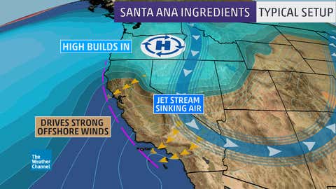
Southern California's mountains don't allow these north-to-northeast winds to simply flow from the high desert to the coast in a straightforward fashion.
Instead, these winds are forced to squeeze and accelerate through mountain passes and canyons, such as the Santa Clara River Valley (including Interstate 5 northwest of downtown L.A.), Cajon Pass (I-15 north of the Inland Empire), the Santa Ana mountains of Orange County and Banning Pass (I-10 west of Palm Springs).

The strongest winds can be found just below passes and the mouths of these canyons, usually with gusts up to 60 mph. Nearby locations not near a pass or canyon may have light winds.
They usually peak late at night and in the morning, as nighttime cooling of the high desert air only strengthens the pressure difference discussed earlier.
In stronger Santa Ana events, damaging gusts to 70 mph will be more widespread, and the windiest canyons, such as Fremont Canyon in Orange County, will see gusts of 100 mph.

If the weather pattern described earlier remains in place, Santa Ana winds could occur for several days.
These offshore winds aren't simply limited to Southern California. They're known as Diablo winds around the Bay Area, and can also occur along the western slopes of the Sierra.
These damaging events in otherwise sunny skies might be hard to comprehend for those in other parts of the world where such winds usually accompany a storm with rain or snow.
What Impacts These Winds Could Bring
The biggest concern, by far, in most Santa Ana wind events is the danger from wildfires.
What makes them particularly dangerous in October is that they occur when soil moisture is lowest and vegetation driest after the summer dry season.
These Santa Ana winds can whip an existing wildfire, just-developed small brush fire or smoldering campfire into an inferno within minutes or hours.
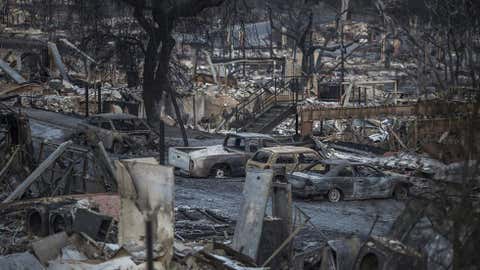
A hot, dry, shifting wind is a nightmare for firefighters anywhere.
The Tubbs Fire, which destroyed 5,636 structures in Napa and Sonoma counties last October, ranks as California's most destructive wildfire, according to Cal Fire. A majority of the most destructive California wildfires have occurred in October.
(MORE: California's Most Destructive Wildfires)
Of course, these high winds can also down trees, knock out power, damage mobile homes, blow cars and trucks off the road and produce areas of blowing dust and reduced visibility.
They also can produce dangerous low-level wind shear and turbulence, as many approaches and climbs after take-off occur over the mountains. They can even be a boating hazard.
In the strongest cases, Santa Ana winds howl well offshore to Catalina, San Clemente and the Channel Islands.
Heavy surf can develop over the waters immediately adjacent to the mouth of canyons, as well as northeast-facing harbors of the aforementioned islands.


