...ACTIVE WEATHER EXPECTED BY THE WEEKEND WITH THE RISK OF SEVERE
THUNDERSTORMS AND POSSIBLY FLASH FLOODING...

An unusually strong upper level disturbance is expected to move
into the area Thursday night through Saturday, bringing the
possibility of very active weather to portions of the Aloha
State. The latest guidance indicates an increasing potential for
strong to severe thunderstorms, which could produce damaging winds
and large hail, as well as the possibility for localized intense
rainfall and flash flooding.

The details of this event, including timing, locations most at risk,
and intensity, are still uncertain. Listen for later statements,
as well as possible watches and warnings, as this event becomes
more clear.
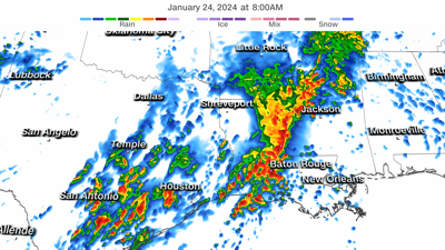
Heavy storms are deluging portions of the South Wednesday morning.
(CNN) — Dangerous flash flooding is ongoing across parts of Texas and Louisiana Wednesday morning as drenching storms deluge the South.
The torrential rainfall is part of a multi-day flood threat that will reach its most concerning level in the region Wednesday .
San Antonio, Beaumont, Texas, and Lake Charles, Louisiana, were just some of the cities where flash flood warnings were issued.
The National Weather Service warned of “life-threatening flash flooding” east of San Antonio Wednesday morning. Between 5 and 7 inches of rain had fallen in this area since Tuesday, with more to come.
A more widespread area of 2 to 4 inches of rain has soaked areas from eastern Texas to Louisiana and southern Arkansas since Tuesday.
Daily waves of warm, moist air will continue to fuel rounds of drenching storms for the South through midweek before wet and dreary conditions expand to a wider area of the eastern US by Friday and Saturday.
The area of greatest concern for flash flooding will expand across more of Louisiana and reach parts of Mississippi as Wednesday progresses. A Level 3 out of 4 risk for excessive rainfall is in place for these areas Wednesday.
Moisture surging north from the Gulf of Mexico is increasing the flood threat across the South.
Widespread rainfall totals of 4 to 6 inches are likely. Higher totals will focus on areas closer to the Gulf of Mexico where multiple rounds of heavy rain and a few thunderstorms unfold.
Parts of Louisiana and Mississippi – some of the most parched areas of the region – could end the week with inches of rainfall bordering on double digits.
Rainfall of this nature can easily lead to flash flooding, especially in drought-stricken areas, because the ground is dry and hard, allowing less water to soak into the soil.
Drought conditions cover more than 80% of Mississippi and more than 90% of Louisiana, and over 10% of both states are in exceptional drought – the most severe level of US Drought Monitor scale.
While the rain will become less intense after Wednesday, steady rounds of rain will persist for the entire week across parts of the South.
By Friday and Saturday, rain and will expand tremendously in scope, bringing dreary, wet weather across much of the East.
Around 1 to 2 inches of rain is possible during this time from the central Appalachians through New England.
CNN Meteorologist Rob Shackelford and CNN’s Elizabeth Wolfe contributed to this report.