Flood modelling for Costa Rica’s future – An Ambiental case study
Helping to understand the potential impact of rising sea levels in Costa Rica
The project
In 2015/16, the UK Foreign and Commonwealth Office’s Latin American Fund for Science and Technology financed nine science and innovation projects in Costa Rica to the total of £1 million. One of the aims of the funding was to boost both countries’ capacities to deal with global challenges such as climate change and energy security.
To meet this aim, one of the projects funded was a review of how climate change and rising sea levels would impact the Caribbean coast of Costa Rica. It was proposed and undertaken by the Setecoop Group, a Costa Rican architectural, engineering and construction company that specialises in large-scale infrastructure projects.
Setecoop came to Ambiental for the tools and training to tackle the project.
Our approach
The Setecoop team needed flood modelling software that would enable them to simulate flood events that took into account rivers, rainfall and tidal waters. They identified Ambiental’s flood simulation software, Flowroute-i™ as a suitable tool.
Tools
Flowroute-i™ is designed specifically for complex environments. The technology models the interaction of pluvial (surface), fluvial (river) and tidal water sources, considering drainage, infiltration and groundwater levels. Flowroute-i is used by Ambiental to generate data sets for specific countries, regions and local sites or it can be used by clients as an executable software program.
In this case, the Setecoop team needed to use Flowroute-i themselves to model all the rivers in Costa Rica and investigate how rising sea levels would impact the country. They needed to input their own rainfall, tidal and flows data as well as terrain, land use, and soil type data.
We agreed flexible licensing so that the team could the use Flowroute-i for the term of the project.
Bespoke training
Setecoop sent three delegates for training in the UK: Managing Director Rolando Vega, engineer Adrián Fernández, and hydrologist Caroline Huguenin. Each had different goals and levels of experience, so we tailored our three-day training programme to cover all of their objectives and to be accessible to them all.
By the end of the three days they understood how they could use Flowroute-i to set up and run flood simulations, including multiple outputs and boundary conditions. They also understood how to check and troubleshoot their models, and knew how to interpret the results and post-process the data appropriately.
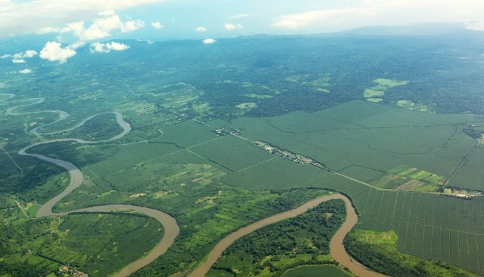
We spent two of the three days using their data to model the Sixaola River, which forms part of the Costa Rican border with Panama. This gave them hands on experience of using the software to achieve goals that were specific to their project.
By the end of day three they had all the necessary knowledge and tools to produce flood models for any region where they had the necessary input data.
Ongoing support
Work on the project did not start immediately and so when it did get underway some re-familiarisation with the software was needed. We provided ongoing support until the team was confident working independently, and continue to support them with any queries they may have.
The outcome
The project was finished on time, and the results were presented at a Science and Innovation Fair at the British Embassy in Costa Rica in March 2016. There was a great deal of interest in the results, and Setecoop will continue to use the software for future projects and to model other parts of the country.
Testimonial
“I have learned a lot since day one! The three-day training programme is perfect for people who have a relative understanding of GIS software and a basic knowledge of flood modelling. In our training each participant worked individually on a computer, preparing the data and running different simulations. This was a great way to understand how Flowroute-i works..
The program in itself is very easy and straightforward to use. After preparing the data in folders and choosing the interval and length of the output, the program does it all by itself. The depths and velocities can be visualised through the outputs. One great advantage of Flowroute-i is that the data needed is still quite accessible, which is good for situations (and countries) where data is difficult to get.
Even being on the other side of the world, in a different time zone, the customer support was very good. No matter what the issue (GIS or Flowroute-i related), Ambiental’s team was always very quick to respond. Through step-by-step instructions (often with print screens of the steps) or emails, it was possible to solve all the issues I encountered.”
– Caroline Huguenin, Hydrologist, Setecoop, Costa Rica
Ambiental training
Ambiental provides tailored training in flood modelling and flood risk assessment as well as in disaster risk assessment. We help clients to better understand, analyse and respond to risks from natural hazards such as floods, landslides, tropical cyclones and earthquakes.
We can provide training either in the UK or abroad. On-going support and advice is included in all our training packages.
Contact us
For more information, pricing and to commission a training needs analysis,
please contact Dr Justin Butler:
+(44) 203 857 8545 • info@ambiental.co.uk • www.ambiental.co.uk
Blog photo
Potential flooding on the Sixaola River, above, was modelled using Flowroute-i™
CEO at Instech - insights from and for a network of 25,000 people driving innovation in insurance and risk management around the world. Podcast host. Board advisor.
8yJustin, congratulations to you and the Ambiental team for creating a practical flood analytical solution to a country where no such models existed. One more important step to help towards to addressing the insurance protection gap.