
Machine Learning in geology holds a great deal of promise as a tool for improving the efficiency and quality of geological investigation, interpretation and modelling. It’s currently evolving quickly and will mature to deliver exceptional value for exploration and mining.
Imago, now part of Seequent, is working with companies around the globe to develop Machine Learning (ML) using geoscientific images, including improving the process and workflows to use the outcomes of ML.
ML is the concept of training a computer to classify, count or predict based on data inputs. Advances in the capture and quality of images, together with cloud computing has led to the opportunity to combine drilling core and chip images with ML to help geologists make faster, more accurate decisions.
In this blog, we’ll outline how you can get your geoscientific images ready for ML, uncover more value and insights and make more discoveries!
Steps to ML using Geological Images
To start identifying the problems and opportunities you want to solve with ML you first need to make sure your image data is ready, is of a consistent high quality and is easily accessible. To sustain this approach, systemise your image capture and cataloguing and how images connect with other geological processes.
Step 1.
Establish an efficient workflow for capturing and cataloguing consistent, high-quality photographs.
Step 2.
Build a Cloud library fit for ML.
When you’re dealing with multiple very large files the Cloud provides the unlimited file size handling and storage capacity you need whilst making sure images are instantly accessible and distributable to Cloud based models and to a user’s browser.
Step 3.
Integrate the image library with the daily tools and tasks of the geology team.
This not only provides instant access for geology and drilling supervision, provides the image viewing tools needed for collaboration but integrating your high-quality images with existing workflows will help you and your team understand the current value and further potential value from ML.
Step 4.
Clarify the problem/opportunity and value of potential ML projects and review the potential of the available data to solve the problem/opportunity. Examples include:
- Identify instances of poor classification of critical lithological units during manual logging.
- Determine the percentage of mineral types that are visually distinctive, such as sulphides.
- Quantify vein density and characteristics.
- Estimate geomechanical properties from images.
- Verify structures, RQD.
- Crop and lineralise images.
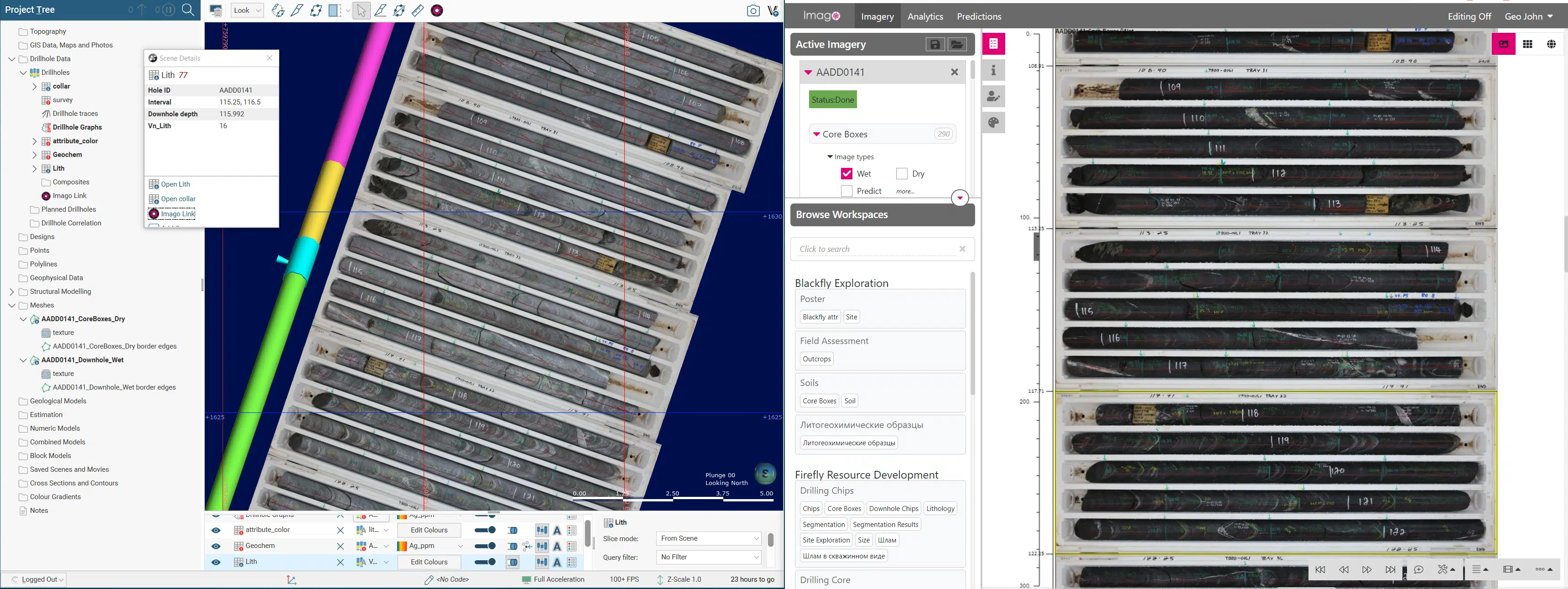
Core boxes displayed in Imago’s platform (right) and in Leapfrog (left). The geologist clicks the drill hole trace to display the corresponding core photos in Imago as a drill hole at the correct depth enabling validation of logs and assays. Access to geoscientific images provides rich information that supports interpretation and modelling and helps identify problems to solve with ML.
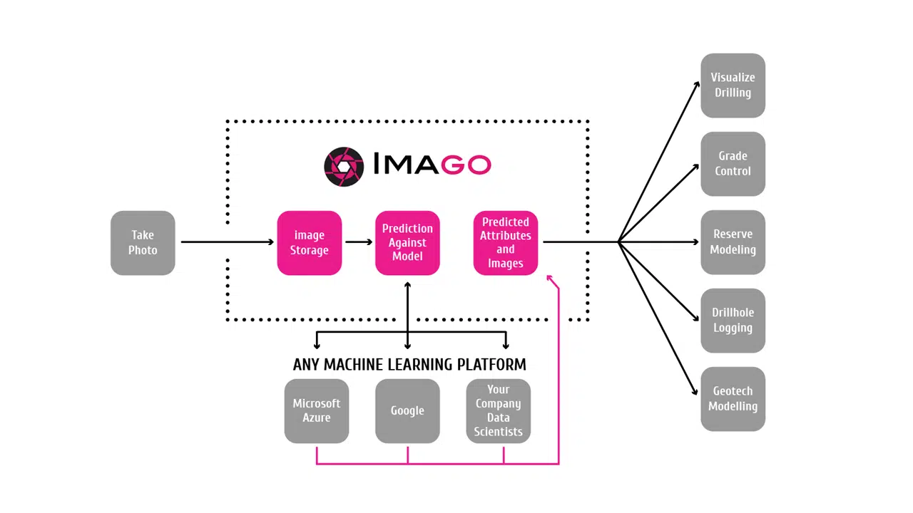
Imago provides an image capture workflow to achieve consistent, high-quality images that are then automatically catalogued and stored in the Imago Portal ready for your journey to ML. With Imago you can:
- Automate the cataloguing of core imagery with the right project, core box number, depth from and to.
- Automate the cropping of core box photos, stitching the core runs together, rotating them 90 degrees to view as one continuous core downhole alongside other datasets such as a televiewer imagery or assays.
- Integrate with Leapfrog and other geological and modelling tools to provide instant viewing of images to support and validate geological decisions.
- Export annotations that have been created within the Imago Portal to train models.
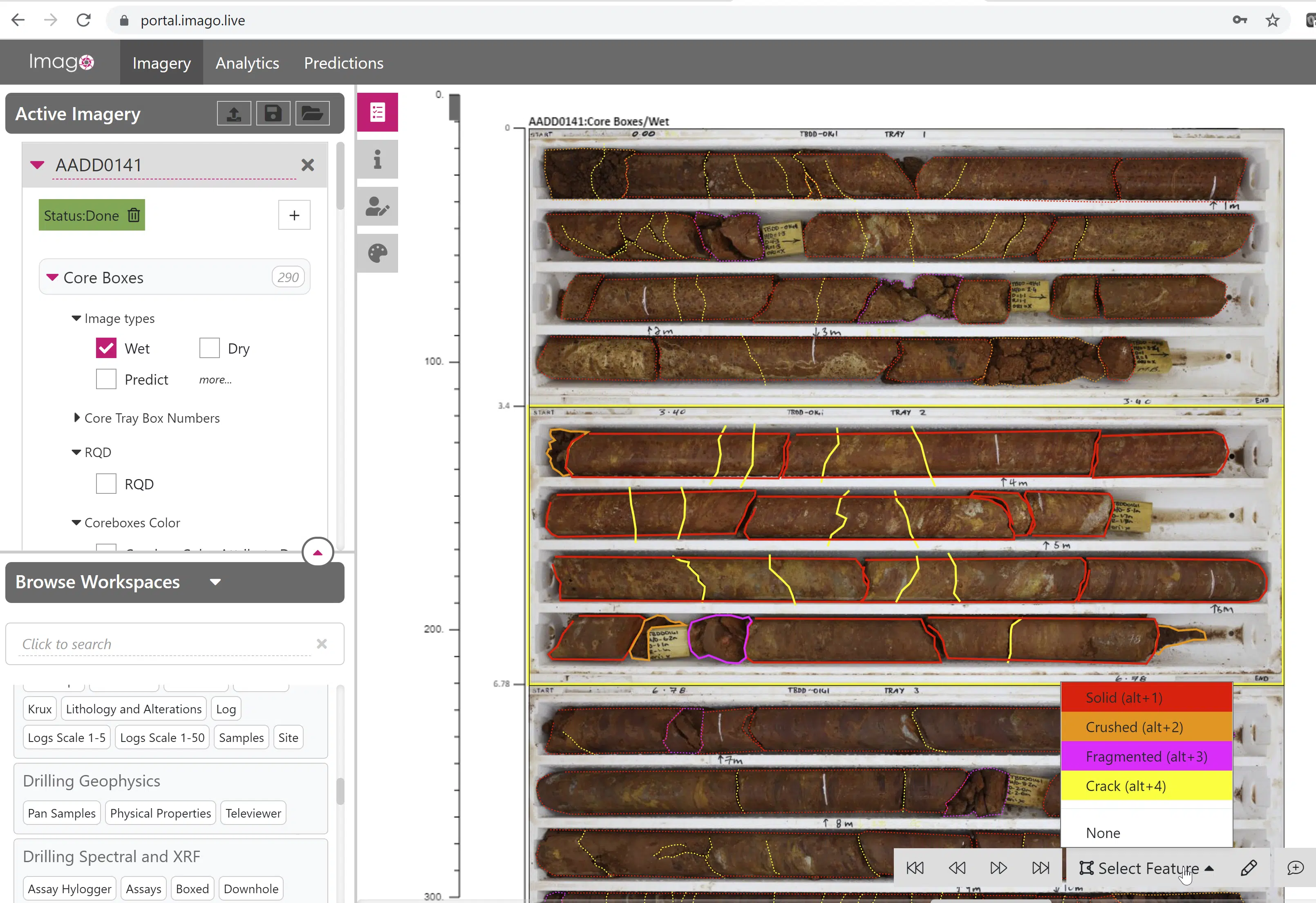
Masking and classifying in the Imago Portal.
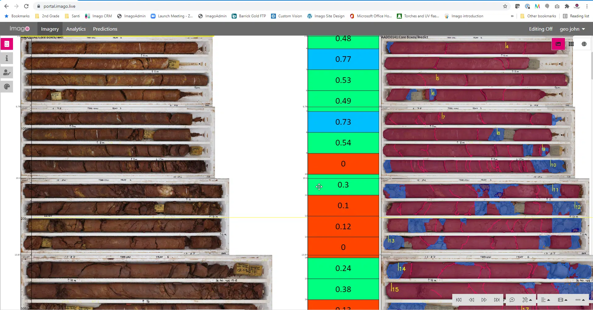
On the left is the original core photos, on the right are core conditions predictions. The middle represents the estimated Imago RQD value, which can be exported as an attribute to a csv file.
Watch ML in action in this 20-second video. Imago ML Segmentation

Imago’s founder, Federico Arboleda, concludes, “Imago establishes a consistent process for capturing high quality images, which integrate with existing workflows, and allow problems to be identified. The geoscientific images provide rich information that supports interpretation and modelling with the future opportunity of automating logging and validating workflows.”