The Old Corpse Road links the isolated hamlet of Swindale Head in Mosedale with Mardale. It's a bleak but beautiful crossing of a piece of sometimes boggy moorland, with views to High Street and Harter Fell.
- Pathways
- by David Stewart, Nicholas Rudd-Jones
-


- Tell us what you think: Star-rate and review this book
Although there was a church in Mardale, it was only allowed its own cemetery in the 1700s. Until that time the bodies were carried all the way from Mardale, over the hill to Swindale Head, and then a further trek of several miles over slightly less difficult ground to the church at Shap.
Shap had its own abbey and so the church in the village no doubt assumed rightful dominance over all the surrounding valleys. Mardale was allowed to build a small oratory by the monks at Shap, later replaced by a tiny church with a steeple just 8.5m high. Finally, permission was granted for the church in Mardale to bury its own dead. The last body to be carried to Shap by the corpse road was that of John Holme on 17 June, 1736.
The minuscule Mardale church has now disappeared under the waters of Haweswater. The whole valley was flooded in the mid-1930s after the building of a dam at the northern end. The existing lake grew over threefold in surface area, swallowing up the tiny church, several farms and the Dun Bull Hotel. Nowadays such a development in the national park would be met with an outcry, but back in the 1930s there was simply sadness and resignation. At the last service in the church on 18 August, 1935 the Bishop of Carlisle spoke to the 72 people who could fit inside. Outside over 1,000 stood in the fields and listened as the service was relayed over loudspeakers. The church was dismantled before the flooding, with some of its stones and window lintels used to build the outflow tower that juts out into the reservoir. The bodies in the cemetery were disinterred and moved to Shap church, where they have their own corner near the railway line. So Shap church claimed them in the end.
If you are lucky you will see the one remaining golden eagle of the valley circling above. There used to be a breeding pair but the female was found dead several years ago. The failure of the male to attract a new partner may be down to lack of carrion. In the past, the carcasses of sheep and deer were left to rot on the hillsides, providing a source of food capable of supporting two adults and their young. Now, mindful of the look of the environment and contamination of the drinking supplies in the reservoir, the landowners clear them away. It is difficult to imagine that the occasional dead animal could have much effect on the water or that tourists would care more about an unsightly carcass than about the glorious sight of a family of golden eagles soaring on the updrafts, scanning the ground below for a meal.
THE ROUTE
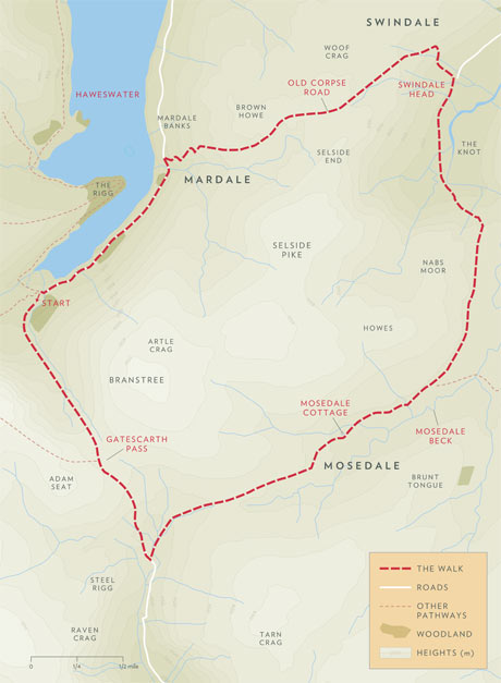 Map: Darren Bennett
David Stewart retraces a route he has walked many times, along an ancient corpse road on the outlying hills of the Lake District
We discovered this nine-mile walk more or less by accident while looking for a decent circular route from Haweswater that did not reach right up to the higher fells. It was mid-winter, we had four young children and the weather forecast did not look too promising. It's a fabulous walk and we have done it many times since, in all weathers.
On that first walk three of our children opted out before we even started – a sensible choice, as it turned out. It was left to the three blokes – old colleague Warren Baxter, our teenage son Greg and me – to complete the route we had traced out on the map. We took the more obvious path out of the head of the valley, a track leading over Gatescarth Pass towards Longsleddale. This would have been a standard packhorse trail heading south from Mardale towards the market town of Kendal, a route for the living rather than the dead. From the southern tip of Haweswater it climbs steadily towards the pass, the dark crags of Harter Fell dominating on the right and a tumbling stream on your left.
The track down from Gatescarth Pass is easy going. Then we turn left to navigate through a wide valley, heading slightly upwards to an indistinct shoulder leading into Mosedale. Walking through here on that winter day, our prospects began to darken, literally. It started to rain. The valley is deserted at the best of times and on a poor day you are unlikely to meet another traveller. The path is easily lost in the grass and reeds: it needs more feet to keep it well marked.
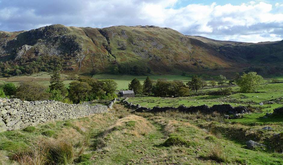
Eventually an unlikely-looking property comes into sight, the single-storied Mosedale Cottage. No doubt at one time a shooting lodge – it is difficult to imagine any other purpose for it – it is now a bothy under the protection of the Mountain Bothies Association. As such it can be used by anyone passing by who needs shelter for the night, free of charge.
We clamber down a steep escarpment into Swindale. Mosedale Beck transforms into Swindale Beck as it enters the valley and meanders towards the few buildings of Swindale Head. Over the centuries the river has thrown up high banks of sediment, providing a welcome dry parapet along which to walk above the wetter ground.
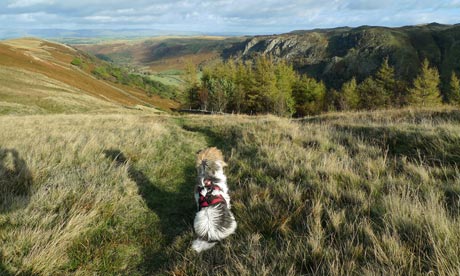 The path down to Swindale Head. Photograph: David Stewart/Nicholas Rudd-Jones
Swindale Head remains delightfully remote. With no parking for walkers – cars have to be left more than a mile further up the valley – the farmhouse is as isolated as it has been for centuries. The path to Mardale is signed directly opposite the house. It climbs directly up the hillside for a couple of hundred yards and then, crossing a stream, does a single long zigzag to cross the same stream again 50m or so higher up. Until the descent into Mardale this is the last time the path looks constructed, cut into the slope of the hill.
After the stream it is simply a faint line trodden into the grass. Behind, on a good day, the valley is a patchwork of colours, from the green fields by the river, to the greys of Outhlaw and Gouther Crags on the opposite flank and the darker hues of heather between.
After a mile or so on a fairly featureless felltop, the path begins its steep descent back to Haweswater, in a series of hairpin bends. A spectacular waterfall crashes down the hillside on the left. For years we had wrongly assumed that corpses were taken from the tiny settlement of Swindale Head to the church in Mardale, which seemed logical enough. But we were mistaken: the corpse route went the other way, out of the Mardale valley, through Swindale Head and on to Shap. Climbing these bends complete with corpse must have been hard work at the best of times. This maybe explains why the practice here was to strap the body onto a pony, encased in a simple shroud rather than a coffin.
Sometimes, in periods of drought, it's possible to look down to Haweswater and see lines of walling just below the surface. Very occasionally the reservoir drains to such an extent that the walls and the remains of a few houses, including the old inn, resurface and it's possible to walk the field paths again. It is, of course, a stony experience as there is never time for any vegetation to grow. It is almost like walking through the skeleton of the place.
Coming down the zigzag path we reach the road, constructed in the 1930s along with the dam. To our right is the Haweswater Hotel, built to replace the drowned Dun Bull Inn. Voices at the time pointed out that, as a hotel, it was misplaced; that it should have been built on the other side of the reservoir so visitors could walk straight out onto the Lakeland Fells. There's no doubt that the hotel has a magnificent view but there are no footpaths directly from its door. Instead there is the road, which some also complained was too wide for its setting. Aesthetically they were absolutely right: it should by rights be no more than a country lane or track, as it leads to no settlement, just the head of the valley. But at least it means you can walk along it with plenty of room for the cars to pass on their way to and from the crowded car park.